Research Training Group 2530
RTG2530Biota-mediated effects on Carbon cycling in Estuaries
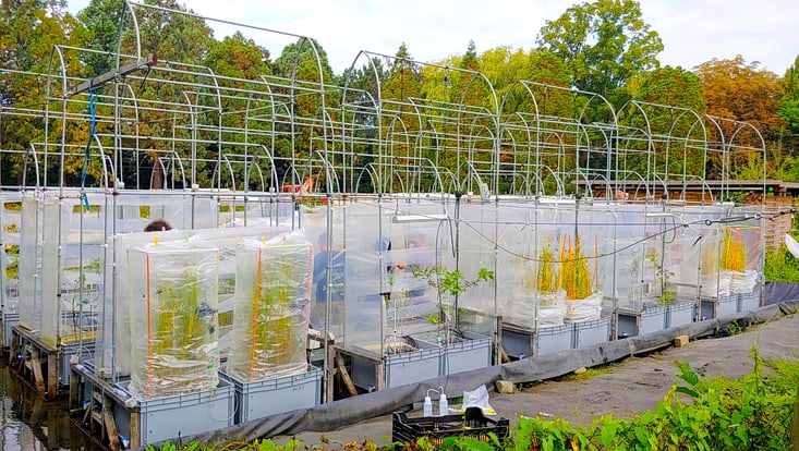
Photo: UHH/Denstorf
6 April 2021, by RTG2530
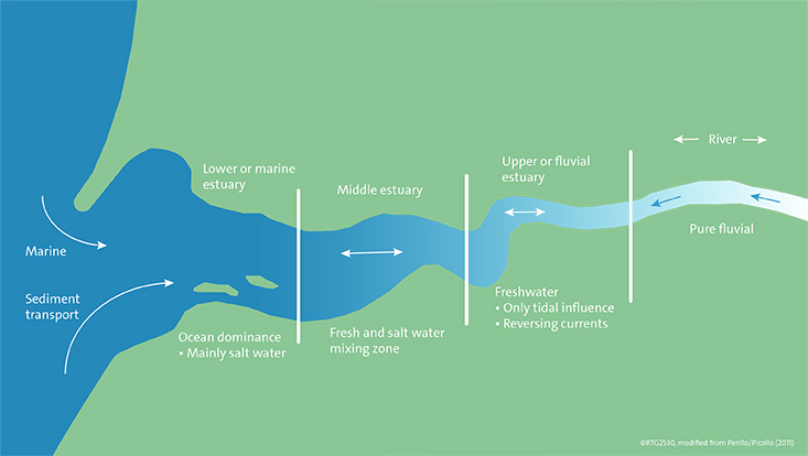
Photo: UHH/RTG2530
The large estuaries of the North Sea, Weser, Ems and Elbe, are over 100 kilometers long and more than ten kilometers wide. It is no surprise that they can be divided into different areas.
Estuaries are partially enclosed coastal bodies with one or more rivers or streams flowing into it. Just to name a few estuaries in Europe: the Seine (France), which flows into the English Channel, the Thames (United Kingdom), which flows into the North Sea as well as the three large estuaries Weser, Ems and Elbe in Germany.
Not only the actual water areas, which mark the transition from the fresh water of the river to the salt water, are part of the estuary. All areas influenced by the tide, such as sands, reeds and salt marshes count as part of it. Overall, the large North Sea estuaries cover a total area of 300 square kilometers. The estuaries can be divided into different zones.
The so-called "lower estuary" or “marine estuary” marks the area where the estuary meets the ocean. This zone is strongly influenced by the tides and dominated by the salt water of the ocean. One feature of the habitat is that it is constantly changing: for example, sand islands and deep gullies form and disappear with the tides.
If you follow the estuary inland, the next zone you reach is the "middle estuary", which is also tidally influenced. Here, fresh and salt water mix, creating a brackish water.
The third and last zone is the "upper estuary" or “fluvial estuary”, which is dominated by fresh water and is still influenced by the tides. Further upstream follows the river, which is no longer influenced by the tides and in which freshwater predominates. The upper limit of the estuary is thus marked by the absence of tidal influence.